
Page 100 - eProceeding - IRSTC & RESPEX 2017
P. 100
Syamsul Anuar / JOJAPS – JOURNAL ONLINE JARINGAN COT POLIPD
Camera Parameter: Canon PowerShot SX230 HS digital camera
Focal Length 4.647674 mm K1 – radial distortion 1 0.0009059
Xp – principal point x 3.155800 mm K2 – radial distortion 2 -0.0000173
Yp – principal point y 2.395994 mm K3 – radial distortion 3 0.0000000
Fw – format width 6.196596 mm P1 – decentering distortion 1 -0.0009214
Fh – format height 4.648200 mm P2 – decentering distortion 2 0.0011280
Basically, the minimum two persons are needed to do the autonomous UAV. One person will act as operator that will control
UAV during launching and landing while the other person will monitor the UAV behavior and also to make sure UAV at the
right flight line during flying mission. The UAV images will be captured by using digital camera that attached below the UAV.
Ground control point (GCP) normally established after the aerial photography has been done. Several GCPs were selected refer
to UAV images which enclosed the overlapped area.
In this study, height coordinates at UAV images and in field refers to mean sea level (MSL) or orthomertic height. For the
data acquisition, GPS Real Time Kinematic technique was used for the determination of ground control points and check points
at the study area. Leveling observation is carried out to establish vertical control point. In this study, the leveling observation is
carried out from the point with known height value to the GCPs and CPs at the study area. There are 28 photos or UAV images
were used for orthophoto and DEM generation using Agisoft PhotoScan software. Ground control point’s data obtained from
leveling method is used along the processes in order to generate photogrammetric products.
3. Data Processing
The processing of UAV data can be separated into two (2) stages. The first stage of processing is to create digital orthophoto
and DEM by using Agisoft PhotoScan. Global Mapper software is applied for analysis in the second stage. The steps or the
procedures involved in the processing using Agisoft PhotoScan software are setting the parameter, add photo, align photo,
remove spark, build geometry, build texture, export orthophoto, export DEM and add GCP. More ground control point makes the
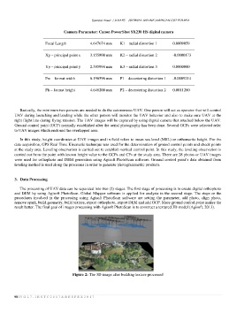
result better. The final goal of images processing with Agisoft PhotoScan is to construct a textured 3D model (Agisoft, 2013).
Figure 2: The 3D image after building texture processed
98 | V O L 7 - I R S T C 2 0 1 7 & R E S P E X 2 0 1 7