
Page 44 - The World About Us
P. 44
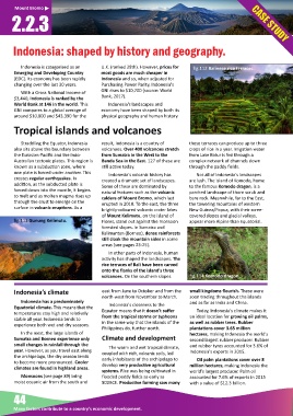
Mount Bromo
      2.2.3


      Indonesia: shaped by history and geography.


          Indonesia is categorised as an   U.K. (ranked 28th). However, prices for         fig.112 Balinese rice terraces.
       Emerging and Developing Country    most goods are much cheaper in
       (EDC). Its economy has been rapidly   Indonesia and so, when adjusted for
       changing over the last 30 years.   Purchasing Power Parity, Indonesia's
                                          GNI rises to $10,700 (source: World
          With a Gross Na onal Income of
       $3,440, Indonesia is ranked by the   Bank, 2017).
       World Bank at 146 in the world. This   Indonesia's landscapes and
       GNI compares to a global average of   economy have been shaped by both its
       around $10,800 and $43,390 for the   physical geography and human history.

       Tropical islands and volcanoes


          Straddling the Equator, Indonesia   result, Indonesia is a country of   these terraces can produce up to three
       also sits above the boundary between   volcanoes. Over 400 volcanoes stretch   crops of rice in a year. Irriga on water
       the Eurasian-Pacific and the Indo-  from Sumatra in the West to the     from Lake Batur is fed through a
       Australian tectonic plates. This region is   Banda Sea in the East. 127 of these are   complex network of channels down
       known as a subduc on zone, where   s ll ac ve today.                   through the paddy fields.
       one plate is forced under another. This   Indonesia's volcanic history has   Not all of Indonesia's landscapes
       creates regular earthquakes. In    created a drama c set of landscapes.   are lush. The island of Komodo, home
       addi on, as the subducted plate is   Some of these are dominated by    to the famous Komodo dragon, is a
       forced down into the mantle, it begins   natural features such as the volcanic   parched landscape of thorn scrub and
       to melt and as molten magma rises up   caldera of Mount Bromo, which last   bare rock. Meanwhile, far to the East,
       through the crust to emerge on the   erupted in 2010. To the east, the three   the towering mountains of western
       surface in volcanic erup ons. As a
                                          brightly-coloured volcanic crater lakes   New Guinea/Papua, with their scree-
                                          of Mount Kelimutu, on the island of   covered slopes and glacial valleys,
          fig.113 Gunung Kelimutu.         Flores, stand out against the monsoon   appear more Alpine than Equatorial.
                                          forested slopes. In Sumatra and
                                          Kalimantan (Borneo), dense rainforests
                                          s ll cloak the mountain sides in some
                                          areas (see pages 23-25).
                                             In other parts of Indonesia, human
                                          ac vity has shaped the landscapes. The
                                          rice terraces of Bali have been carved
                                          onto the flanks of the island's three
                                          volcanoes. On the southern slopes         fig.114 Komodo dragon.


       Indonesia’s climate                east from June to October and from the   small kingdoms flourish. These were
                                          north-west from November to March.  soon trading throughout the islands
          Indonesia has a predominately                                       and as far as India and China.
       Equatorial climate. This means that the   Indonesia's closeness to the
       temperatures stay high and rela vely   Equator means that it doesn't suffer   Today, Indonesia's climate makes it
       stable all year. Indonesia tends to   from the tropical storms or typhoons   an ideal loca on for growing oil palms,
       experience both wet and dry seasons.   in the same way that the islands of the   as well as rubber trees. Rubber
                                          Philippines do, further north.      planta ons cover 3.65 million
          In the west, the large islands of                                   hectares, making Indonesia the world's
       Sumatra and Borneo experience only   Climate and development           second largest rubber producer. Rubber
       small changes in rainfall through the                                  and rubber tyres accounted for 3.6% of
                                             The warm and wet tropical climate,
       year. However, as you travel east along   coupled with rich, volcanic soils, led   Indonesia's exports in 2015.
       the archipelago, the dry season tends   early inhabitants of the archipelago to
       to become more pronounced. Cooler   develop very produc ve agricultural   Oil palm planta ons cover over 8
       climates are found in highland areas.                                  million hectares, making Indonesia the
                                          systems. Rice was being cul vated in   world's largest producer. Palm oil
          Monsoons (see page 89) bring    flooded paddy fields as early as      accounted for 7.6% of exports in 2015
       moist oceanic air from the south and   800BCE. Produc ve farming saw many   with a value of $12.3 billion.


       44

       Many factors contribute to a country’s economic development.