Page 1209 - Chief Architect Reference Manual
P. 1209

Chief Architect X10 Reference Manual


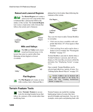
                         Raised and Lowered Regions             plateau but is level rather than following the
                                                                contours of the terrain.
                                 The Raised Region tool creates a
                                 raised area with a top surface that
                        is flattened like a plateau but follows the   Flat Region
                        surface of the terrain. The Lowered Region
                        tool creates a depression with a bottom that
                        follows the terrain and is flattened.
                                                                                            Raised
                                                                 Lowered                    Region
                                                                 Region

                                                                There are two ways to add a Terrain Modifier
                                                    Raised      to your plan:
                         Lowered                    Region
                         Region                                 • Click once to place a modifier with end-
                                                                  points that form a 10’ (4 m) square at that
                                 Hills and Valleys                location.
                                                                • Click and drag from end to end to draw a
                                 The Hill and Valley tools create   feature sized as needed. See “Rectangular
                                 raised and lowered areas in the   Polyline” on page 317.
                        terrain that come to a point rather than
                        flattening at their highest or lowest   Terrain Modifiers can only be drawn when a
                        elevations.                             Terrain Perimeter is present, and will only
                                                                display in 3D when they are drawn within the
                                                                perimeter. See “Displaying Terrain” on page
                                                                1213.
                                                                Once created, Terrain Modifiers can be
                                                      Hill      selected and edited in a variety of ways. See
                         Valley                                 “Editing Spline Based Objects” on page 239.


                                   Flat Regions                      Terrain  modifiers  can  be  blocked  with
                                                                     images  and  stored  in  the  library  for
                             The Flat Region tool creates an area   future  use.  See  “Creating  Architectural
                             with a surface that is flattened like a   Blocks” on page 970.


                   Terrain Feature Tools

                             Select Terrain> Feature to access   Terrain Features are useful for creating
                             tools for drawing bounded areas that   landscaping features because they have
                        follow the contours of the terrain rather than   specified heights and materials. You can, for
                        modifying them.                         example, create paths and planting beds with


                   1208
   1204   1205   1206   1207   1208   1209   1210   1211   1212   1213   1214