
Page 1206 - Chief Architect Reference Manual
P. 1206
Elevation Data Tools
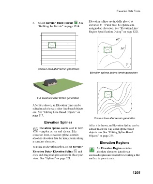
Elevation splines are initially placed at
5. Select Terrain> Build Terrain . See
“Building the Terrain” on page 1214. elevation 0' - 0"and must be opened and
assigned an elevation. See “Elevation Line/
Region Specification Dialog” on page 1221.
60"
36"
0"
Contour lines after terrain generation
Elevation splines before terrain generation
Full Overview after terrain generation
After it is drawn, an Elevation Line can be
edited much the way other line-based objects
can. See “Editing Line Based Objects” on
page 217.
Contour lines after terrain generation
Elevation Splines
After it is drawn, an Elevation Spline can be
Elevation Splines can be used to form edited much the way other spline-based
complex curves and shapes. Like objects can. See “Editing Spline Based
elevation lines, elevation splines contain Objects” on page 239.
absolute elevation data for many points along
a constant elevation. Elevation Regions
To place an elevation spline, select Terrain>
An Elevation Region contains
Elevation Data> Elevation Spline and absolute elevation data for an
click and drag multiple sections in floor plan enclosed region and is ideal for creating a flat
view. See “Splines” on page 321. surface in your terrain.
1205