
Page 1205 - Chief Architect Reference Manual
P. 1205
Chief Architect X10 Reference Manual
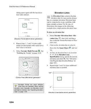
dialog opens again with the last eleva- Elevation Lines
tion value entered.
An Elevation Line contains absolute
elevation data for many points along a
line at a constant elevation. Elevation lines
can be connected to create a polyline with
many straight sections. For the sake of
illustration, the images in the following
example show single-section elevation lines.
To draw an elevation line
1. Select Terrain> Elevation Data> Ele-
Elevation Points before terrain generation vation Line , then click and drag a
line inside the Terrain Perimeter in floor
plan view.
4. Repeat steps 1, 2 and 3 to place addi-
tional elevation points with varied eleva- 2. Click on the elevation line to select it,
tion values as needed. then click the Open Object edit but-
ton.
5. Select Terrain> Build Terrain . See
“Building the Terrain” on page 1214. 3. At first, an elevation line is at elevation
0' - 0". In the Elevation Line
Specification dialog, specify the desired
elevation and click OK. See “Elevation
Line/Region Specification Dialog” on
page 1221.
4. Repeat steps 2 and 3 to draw additional
elevation lines as needed.
120"
Contour lines after terrain generation
Elevation Points are most effective
when they are imported. When adding 0"
elevation data manually, use Elevation Lines
and Splines instead. See “Importing Elevation
Data” on page 1230. Elevation Lines before terrain generation
1204