
Page 1238 - Chief Architect Reference Manual
P. 1238
Importing DXF/DWG Elevation Data
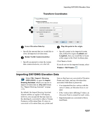
Transform Coordinates
1 Lower Elevation Data by: 3 Map this point to the origin.
• Specify the amount that you would like to • Specify a point in the imported terrain
lower all imported elevation data. data, defined by degrees Latitude and
Longitude, that you would like to locate
2 Rotate North Counterclockwise: at the origin in the Chief Architect plan.
• Specify an amount to rotate the terrain Click Next to finish.
data counterclockwise, or to the left. If you do not see the imported terrain, select
Window> Fill Window .
Importing DXF/DWG Elevation Data
Select File> Import> Drawing lines on that layer are converted to Elevation
(DWG/DXF) to open the Import Points and Lines, and any elevation data
Drawing Assistant, which you can use to associated with them is preserved.
import elevation data in .dwg/.dxf format. • If an imported line has vertices with the
See “Import Drawing Assistant” on page same Z values, an Elevation Line is cre-
1176. ated.
By default, the Import Drawing Assistant • If the vertices have differing Z values, an
imports entities as regular CAD objects; Elevation Point is created for each vertex.
however, you can specify that any layer in • Imported points are converted to Eleva-
the drawing be converted to either a Terrain tion Points.
Perimeter or Elevation Data. If a layer is
converted to Elevation Data, any points and
1237