
Page 1235 - Chief Architect Reference Manual
P. 1235
Chief Architect X10 Reference Manual
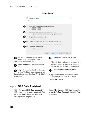
Scale Data
1 The total number of data points to be 4 Change the scale of the terrain.
imported and the ranges of their
coordinates are described here. • Multiply the coordinates of each axis by a
2 Select the Units of measurement used specific number to decrease or increase
for each axis. the relative size or relief of your terrain.
3 Map a data point in the file to the origin 5 Rotate North Counterclockwise:
in Chief Architect to position the terrain
data relative to your plan. See “3D Drafting” • Specify an amount to rotate the terrain
on page 32. data counterclockwise, or to the left.
Click Next to finish.
Import GPS Data Assistant
The Import GPS Data Assistant Select File> Import> GPS Data to open the
allows you to import terrain data from Import GPS Data Assistant, then click Next
the standard .gpx file format. See “GPS to continue.
Exchange Files” on page 1231.
1234