
Page 1234 - Chief Architect Reference Manual
P. 1234
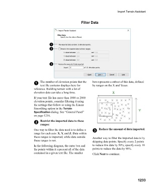
Import Terrain Assistant


                                                               Filter Data


                                1   The number of elevation points that the   box represents a subset of this data, defined
                                    text file contains displays here for   by ranges on the X and Yaxes.
                               reference. Building terrain with a lot of
                               elevation data can take a long time.

                               If your text file has more than 1000 or 2000
                               elevation points, consider filtering it using
                               the settings that follow or using the Linear
                               Smoothing option in the Terrain
                               Specification dialog. See “General Panel”
                               on page 1216.

                                2   Restrict the imported data to these
                                    ranges:
                               One way to filter the data used is to define a   3  Reduce the amount of data imported.
                               range for each axis: X, Y, and Z. Data within
                               these ranges is imported, while data outside   Another way to filter the imported data is by
                               these ranges is not.                    skipping data points. Specify every 2 points
                               In the following diagram, the outer box and   to reduce this data by 50%; specify every 10
                               the points within it represent all of the data   points to reduce the data by 90%.
                               contained in a given text file. The smaller   Click Next to continue.


                                                                                                      1233