
Page 1237 - Chief Architect Reference Manual
P. 1237
Chief Architect X10 Reference Manual
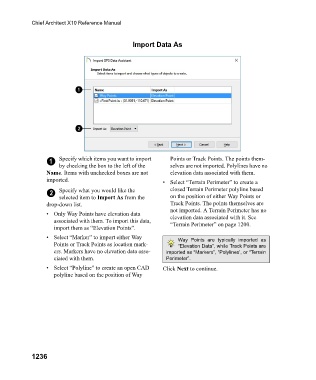
Import Data As
1 Specify which items you want to import Points or Track Points. The points them-
by checking the box to the left of the selves are not imported. Polylines have no
Name. Items with unchecked boxes are not elevation data associated with them.
imported. • Select “Terrain Perimeter” to create a
2 Specify what you would like the closed Terrain Perimeter polyline based
selected item to Import As from the on the position of either Way Points or
drop-down list. Track Points. The points themselves are
not imported. A Terrain Perimeter has no
• Only Way Points have elevation data elevation data associated with it. See
associated with them. To import this data, “Terrain Perimeter” on page 1200.
import them as “Elevation Points”.
• Select “Marker” to import either Way Way Points are typically imported as
Points or Track Points as location mark- “Elevation Data”, while Track Points are
ers. Markers have no elevation data asso- imported as “Markers”, “Polylines’, or “Terrain
ciated with them. Perimeter”.
• Select “Polyline” to create an open CAD Click Next to continue.
polyline based on the position of Way
1236