
Page 310 - PPL-engelsk 2025
P. 310
Meteorology
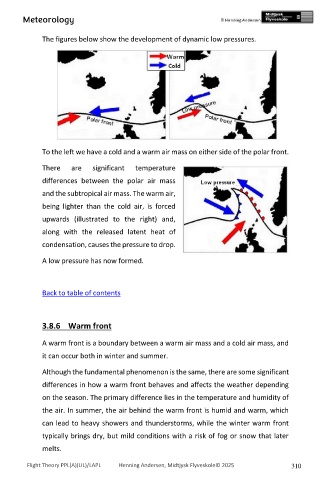
The figures below show the development of dynamic low pressures.
To the left we have a cold and a warm air mass on either side of the polar front.
There are significant temperature
differences between the polar air mass
and the subtropical air mass. The warm air,
being lighter than the cold air, is forced
upwards (illustrated to the right) and,
along with the released latent heat of
condensation, causes the pressure to drop.
A low pressure has now formed.
Back to table of contents
3.8.6 Warm front
A warm front is a boundary between a warm air mass and a cold air mass, and
it can occur both in winter and summer.
Although the fundamental phenomenon is the same, there are some significant
differences in how a warm front behaves and affects the weather depending
on the season. The primary difference lies in the temperature and humidity of
the air. In summer, the air behind the warm front is humid and warm, which
can lead to heavy showers and thunderstorms, while the winter warm front
typically brings dry, but mild conditions with a risk of fog or snow that later
melts.
Flight Theory PPL(A)(UL)/LAPL Henning Andersen, Midtjysk Flyveskole© 2025 310