
Page 308 - PPL-engelsk 2025
P. 308
Meteorology
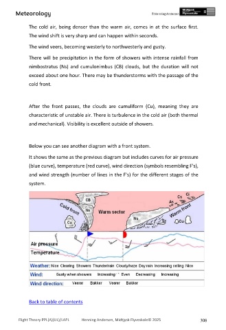
The cold air, being denser than the warm air, comes in at the surface first.
The wind shift is very sharp and can happen within seconds.
The wind veers, becoming westerly to northwesterly and gusty.
There will be precipitation in the form of showers with intense rainfall from
nimbostratus (Ns) and cumulonimbus (CB) clouds, but the duration will not
exceed about one hour. There may be thunderstorms with the passage of the
cold front.
After the front passes, the clouds are cumuliform (Cu), meaning they are
characteristic of unstable air. There is turbulence in the cold air (both thermal
and mechanical). Visibility is excellent outside of showers.
Below you can see another diagram with a front system.
It shows the same as the previous diagram but includes curves for air pressure
(blue curve), temperature (red curve), wind direction (symbols resembling F's),
and wind strength (number of lines in the F's) for the different stages of the
system.
Back to table of contents
Flight Theory PPL(A)(UL)/LAPL Henning Andersen, Midtjysk Flyveskole© 2025 308