
Page 311 - PPL-engelsk 2025
P. 311
Meteorology
3.8.6.1 Summer warm front
In summer, the warm air mass is often humid and can bring rain and
thunderstorms when it meets the colder air. This front generally leads to high
humidity and can result in hot and unstable weather.
3.8.6.2 Winter warm front
In winter, the warm air mass is often dry and can lead to milder, but also foggy
weather, when it moves over a colder surface. Rain may occur, but it is more
likely to be snow, which later melts.
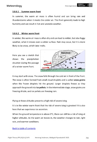
Here you see a sketch that
shows the precipitation
situation during the passage
of a winter warm front.
It may start with snow. The snow falls through the cold air in front of the front.
The snow is often formed from small cloud droplets and is called snow grains
when the frozen droplets hit the ground. Larger droplets freeze as they
approach the ground into ice pellets. In the intermediate stage, snow grains are
freezing drizzle, and ice pellets are freezing rain.
Flying at these altitudes presents a high risk of severe icing.
It is in the winter warm front that the risk of severe icing is greatest! It is also
here that we experience ice accretion.
When the ground temperature is above 0°C, there can still be a risk of icing at
higher altitudes. As the warm air moves in, the weather changes to rain, light
rain, and warmer conditions.
Back to table of contents
Flight Theory PPL(A)(UL)/LAPL Henning Andersen, Midtjysk Flyveskole© 2025 311