
Page 307 - PPL-engelsk 2025
P. 307
Meteorology
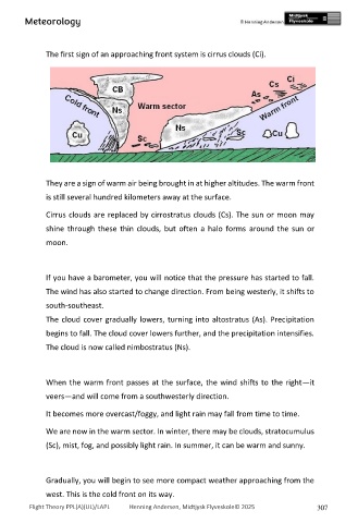
The first sign of an approaching front system is cirrus clouds (Ci).
They are a sign of warm air being brought in at higher altitudes. The warm front
is still several hundred kilometers away at the surface.
Cirrus clouds are replaced by cirrostratus clouds (Cs). The sun or moon may
shine through these thin clouds, but often a halo forms around the sun or
moon.
If you have a barometer, you will notice that the pressure has started to fall.
The wind has also started to change direction. From being westerly, it shifts to
south-southeast.
The cloud cover gradually lowers, turning into altostratus (As). Precipitation
begins to fall. The cloud cover lowers further, and the precipitation intensifies.
The cloud is now called nimbostratus (Ns).
When the warm front passes at the surface, the wind shifts to the right—it
veers—and will come from a southwesterly direction.
It becomes more overcast/foggy, and light rain may fall from time to time.
We are now in the warm sector. In winter, there may be clouds, stratocumulus
(Sc), mist, fog, and possibly light rain. In summer, it can be warm and sunny.
Gradually, you will begin to see more compact weather approaching from the
west. This is the cold front on its way.
Flight Theory PPL(A)(UL)/LAPL Henning Andersen, Midtjysk Flyveskole© 2025 307