
Page 305 - PPL-engelsk 2025
P. 305
Meteorology
3.8.1 Warm fronts and cold fronts
The interface can take two main forms:
- warm front
- cold front
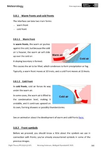
3.8.1.1 Warm Front
In warm fronts, the warm air pushes
against the cold, but because the cold
air is heavier, the warm air will slide
up over the cold air.
A sloping boundary is formed.
This causes the air to be lifted, which condenses to form precipitation or fog.
Typically, a warm front moves at 10 knots, and a cold front moves at 15 knots.
3.8.1.2 Cold Front
In cold fronts, cold air forces its way
under the warm air.
In some cases, the warm air is lifted to
the condensation level, making it
unstable, and it continues upward on
its own, forming showers or possibly thunderstorms.
See an animation about the development of warm and cold fronts here.
3.8.2 Front symbols
Before we proceed, you should know a little about the symbols we use in
connection with fronts; you’ve already encountered symbols in some of the
previous images.
Flight Theory PPL(A)(UL)/LAPL Henning Andersen, Midtjysk Flyveskole© 2025 305