
Page 841 - PPL-engelsk 2025
P. 841
Navigation
When measuring distance on a map, you can do so with a ruler designed for that
purpose, or you can do so by, for example, setting a geometric compass on the
measurement of the distance, and then using the rulers at the bottom of the
map to find the distance in km, SM or NM.
If you want the distance given in NM, you can also use the latitude minutes on
the side of the map.
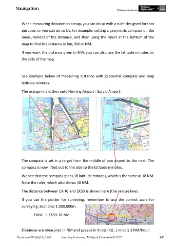
See example below of measuring distance with geometric compass and map
latitude minutes.
The orange line is the route Herning Airport - Spjald Airport.
The compass is set in a target from the middle of one airport to the next. The
compass is now lifted out to the side to the latitude minutes.
We see that the compass spans 18 latitude minutes, which is the same as 18 NM.
Note the ruler, which also shows 18 NM.
The distance between EKHG and EKSD is shown here (the orange line).
If you use the plotter for surveying, remember to use the correct scale for
surveying: Sectional 1:500,000m.
- EKHG → EKSD 18 NM
Distances are measured in NM and speeds in Knots (Kt). 1 knot is 1 NM/hour.
Flyveteori PPL(A)(UL)/LAPL Henning Andersen, Midtjysk Flyveskole© 2025 841