
Page 4 - Aerial Mapping
P. 4
AERIAL MAPPING The excellence of collaboration
Equipment & Softwares Equipment
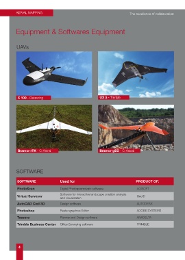
UAVs
X 100 - Gatewing UX 5 - Trimble
Bramor rTK - C-Astral Bramor gEO - C-Astral
SOFTWARE
SOFTWARE Used for PRODUCT OF:
PhotoScan Digital Photogrammetric software AGISOFT
Software for interactive landscape creation analysis
Virtual Surveyor GeoID
and visualization
AutoCAD Civil 3D Design software AUTODESK
Photoshop Raster graphics Editor ADOBE SYSTEMS
Tessera Planner and Design software ANADELTA
Trimble Business Center Office Surveying software TRIMBLE
4