
Page 5 - Aerial Mapping
P. 5
www.moniterra.engineering AERIAL MAPPING
Carried out FLIGHTS on Projects
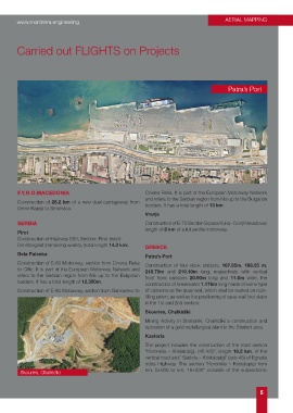
Patra’s Port
F.Y.R.O.MACEDONIA Crvena Reka. It is part of the European Motorway Network
and refers to the Serbian region from Nis up to the Bulgarian
Construction of 28.2 km of a new dual carriageway from borders. It has a total length of 13 km.
Demir Kapija to Smokvica.
Vranje
SERBIA Construction of E-75 Section Srpska Kuka - Donji Neradovac
length of 8 km of a full profile motorway.
Pirot
Construction of Highway E80, Section: Pirot (east)-
Dimitrovgrad (remaining works), (total length 14.3 km). GREECE
Bela Palanka Patra’s Port
Construction of E-80 Motorway, section from Crvena Reka Construction of four dock stations, 167.85m, 188.55 m,
to Ciflic. It is part of the European Motorway Network and 218.70m and 219.10m long, respectively with vertical
refers to the Serbian region from Nis up to the Bulgarian front from caissons 20.90m long and 11.0m wide, the
borders. It has a total length of 12.350m. construction of breakwater 1.176m long made of same type
Construction of E-80 Motorway, section from Bancarevo to of caissons as the quay wall, which shall be seated on rock-
filling prism, as well as the positioning of quay wall foot slabs
in the 1st and 2nd section.
Skouries, Chalkidiki
Mining Activity in Stratoniki, Chalkidiki a construction and
operation of a gold metallurgical plant in the Stratoni area.
Kastoria
The project includes the construction of the road section
“Koromilia – Kristalopigi, (45.4/5)”, length 16.2 km, of the
vertical road axis” Siatista – Kristalopigi” (axis 45) of Egnatia
odos Highway. The section “Koromilia - Kristalopigi from
Skouries, Chalkidiki km. 0+000 to km. 16+200” consists of the subsections:
5