
Page 12 - 2016_ERDAS_IMAGINE_BROCHURE_HexGeo_Print_Neat
P. 12
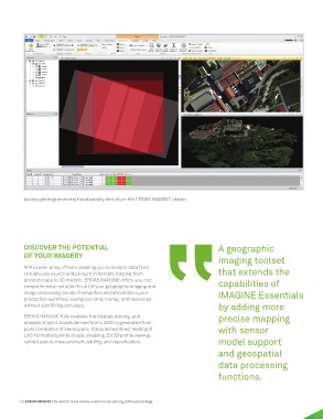
Access photogrammetry functionality directly in the ERDAS IMAGINE ribbon.


          DISCOVER THE POTENTIAL                                                    A geographic
          OF YOUR IMAGERY
                                                                                    imaging toolset
          With a wide array of tools enabling you to analyze data from
          virtually any source and present in formats ranging from                  that extends the
          printed maps to 3D models, ERDAS IMAGINE offers you one                   capabilities of
          comprehensive solution for all of your geographic imaging and
          image processing needs. It simplifies and streamlines your                IMAGINE Essentials
          production workflow, saving you time, money, and resources
                                                                                    by adding more
          without sacrificing accuracy.
          ERDAS IMAGINE fully enables the display, editing, and                     precise mapping
          analysis of point clouds derived from LiDAR or generated from
          point correlation of stereo pairs. It also allows direct reading of       with sensor
          LAS-formatted points clouds, enabling 2D/3D/profile viewing,
          symbolization, measurement, editing, and classification.                  model support
                                                                                    and geospatial

                                                                                    data processing

                                                                                    functions.


        12 | ERDAS IMAGINE The world’s most widely-used remote sensing software package