Page 11 - 2016_ERDAS_IMAGINE_BROCHURE_HexGeo_Print_Neat
P. 11

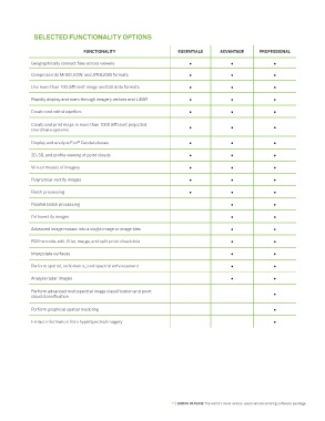
SELECTED FUNCTIONALITY OPTIONS


                                 FUNCTIONALITY                      ESSENTIALS      ADVANTAGE      PROFESSIONAL
             Geographically connect files across viewers                •               •               •

             Compress into MrSID, ECW, and JPEG2000 formats             •               •               •

             Use more than 190 different image and GIS data formats     •               •               •

             Rapidly display and roam through imagery vectors and LiDAR  •              •               •

             Create and edit shapefiles                                 •               •               •

             Create and print maps in more than 1000 different projected    •           •               •
             coordinate systems

                              ®
             Display and analyze Esri  Geodatabases                     •               •               •
             2D, 3D, and profile viewing of point clouds                •               •               •

             Virtual mosaic of imagery                                  •               •               •

             Polynomial-rectify images                                  •               •               •
             Batch processing                                           •               •               •


             Parallel batch processing                                                  •               •
             Orthorectify images                                                        •               •

             Advanced image mosaic into a single image or image tiles                   •               •

             RGB-encode, edit, filter, merge, and split point cloud data                •               •

             Interpolate surfaces                                                       •               •

             Perform spatial, radiometric, and spectral enhancement                     •               •

             Analyze radar images                                                       •               •

             Perform advanced multispectral image classification and point                              •
             cloud classification

             Perform graphical spatial modeling                                                         •

             Extract information from hyperspectral imagery                                             •


                                                                  11 | ERDAS IMAGINE The world’s most widely-used remote sensing software package
   6   7   8   9   10   11   12   13   14   15