
Page 10 - 2016_ERDAS_IMAGINE_BROCHURE_HexGeo_Print_Neat
P. 10
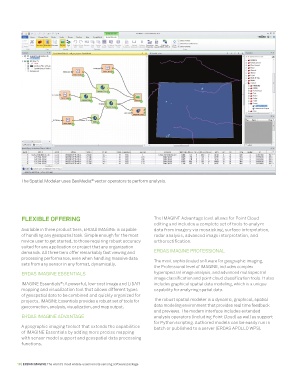
The Spatial Modeler uses GeoMedia  vector operators to perform analysis.
                                       ®


          FLEXIBLE OFFERING                                      The IMAGINE Advantage level allows for Point Cloud
                                                                 editing and includes a complete set of tools to analyze
          Available in three product tiers, ERDAS IMAGINE is capable   data from imagery via mosaicking, surface interpolation,
          of handling any geospatial task. Simple enough for the most   radar analysis, advanced image interpretation, and
          novice user to get started, to those requiring robust accuracy   orthorectification.
          suited for any application or project that any organization
          demands. All three tiers offer remarkably fast viewing and   ERDAS IMAGINE PROFESSIONAL
          processing performance, even when handling massive data   The most sophisticated software for geographic imaging,
          sets from any sensor in any format, dynamically.
                                                                 the Professional level of IMAGINE, includes complex
          ERDAS IMAGINE ESSENTIALS                               hyperspectral image analysis, and advanced multispectral
                                                                 image classification and point cloud classification tools. It also
          IMAGINE Essentials : A powerful, low-cost image and LiDAR   includes graphical spatial data modeling, which is a unique
                          ®
          mapping and visualization tool that allows different types   capability for analyzing spatial data.
          of geospatial data to be combined and quickly organized for
          projects. IMAGINE Essentials provides a robust set of tools for   The robust spatial modeler is a dynamic, graphical, spatial
          geocorrection, analysis, visualization, and map output.   data modeling environment that provides real time feedback
                                                                 and previews. The modern interface includes extended
          ERDAS IMAGINE ADVANTAGE                                analysis operators (including Point Cloud) as well as support
                                                                 for Python scripting. Authored models can be easily run in
          A geographic imaging toolset that extends the capabilities   batch or published to a server (ERDAS APOLLO WPS).
          of IMAGINE Essentials by adding more precise mapping
          with sensor model support and geospatial data processing
          functions.


        10 | ERDAS IMAGINE The world’s most widely-used remote sensing software package