
Page 13 - 2016_ERDAS_IMAGINE_BROCHURE_HexGeo_Print_Neat
P. 13
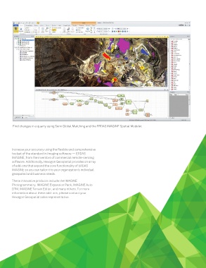
Find changes in a quarry using Semi Global Matching and the ERDAS IMAGINE Spatial Modeler.


        Increase your accuracy using the flexible and comprehensive
        toolset of the standard in imaging software — ERDAS
        IMAGINE, from the inventors of commercial remote-sensing
        software. Additionally, Hexagon Geospatial provides an array
        of add-ons that expand the core functionality of ERDAS
        IMAGINE so you can tailor it to your organization’s individual
        geospatial and business needs.
        These innovative products include the IMAGINE
        Photogrammetry, IMAGINE Expansion Pack, IMAGINE Auto
        DTM, IMAGINE Terrain Editor, and many others. For more
        information about these add-ons, please contact your
        Hexagon Geospatial sales representative.


                                                                  13 | ERDAS IMAGINE The world’s most widely-used remote sensing software package