
Page 13 - Tuskegee Airmen Drone License Preparatory Course Chp.2 Manual
P. 13
• Aeronautical Charts & Chart Supplement
o A Sectional Chart is a pictorial representation of a portion of the earth surface,
showing a lot of information for example color tints that represent various
elevation. Other information includes cities, towns, rivers, railroads, highways.
They also show airports and information about navigation and communication
facilities.
o United States is divided into 87 sections, hence the name “Sectional Chart”
o AS a remote pilot you need to be able to recognize airports on a sectional chart,
let’s take a look at how airports are shown on a sectional chart.
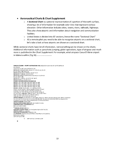
While sectional charts have lot of information, not everything can be shown on the charts.
Additional information such as parachute jumping, glider operations, type of airspace and much
more is published in the Chart Supplement. For example, what airspace Coeur D’Alene airport
in Idaho is within (Fig 31) – – – – – – – – – – – – – – – – – –
COEUR D'ALENE – PAPPY BOYINGTON FLD (COE)(KCOE) P (AR) 9 NW UTC–8(–7DT) N47º46.46´
W116º49.18´
2320 B Class IV, ARFF Index A NOTAM FILE COE
RWY 06–24: H7400X100 (ASPH–GRVD) S–57, D–95, 2S–121, 2D–165
PCN 30 F/B/X/T HIRL 0.6% up NE
RWY 06: MALSR (NSTD) PAPI(P4R)—GA 3.0º TCH 57´.
RWY 24: REIL. PAPI(P4R)—GA 3.0º TCH 47´.
RWY 02–20: H5400X75 (ASPH–GRVD) S–50, D–83, 2S–105, 2D–150
PCN 21 F/B/X/T MIRL
RWY 02: REIL. PAPI(P2L)—GA 3.0º TCH 36´. Rgt tfc.
RWY 20: PAPI(P2L)—GA 3.0º TCH 37´.
RUNWAY DECLARED DISTANCE INFORMATION
RWY 02: TORA–5400 TODA–5400 ASDA–5400 LDA–5400
RWY 06: TORA–7400 TODA–7400 ASDA–7400 LDA–7400
RWY 20: TORA–5400 TODA–5400 ASDA–5400 LDA–5400
RWY 24: TORA–7400 TODA–7400 ASDA–7400 LDA–7400
SERVICE: S4 FUEL 100, JET A OX 1, 2, 3, 4 LGT Rwy 06 NSTD
MALSR, thld bar extends 5´ byd rwy edge lgts each side. ACTIVATE
MIRL Rwy 02–20, HIRL Rwy 06–24, REIL Rwy 02 and Rwy 24,
MALSR Rwy 06—CTAF. PAPI Rwy 02, Rwy 20, Rwy 06, and Rwy 24
opr continuously. MILITARY— FUEL (NC–100, A – Self svc after hr fone
C208–772–6404, C208–661–4174, C208–661–7449, or
C208–699–5433. Self–svc avbl with credit card.)
AIRPORT REMARKS: Attended Mon–Fri 1500–0100Z‡. Aft hrs fuel. Self svc avbl with credit card. 48 hr PPR for unscheduled
ops with more than 30 pax seats call arpt mgr 208–446–1860. Rwy conds not mntd 0100–1500Z‡ dly. Migratory birds
on and invof arpt Oct–Nov. Remote control airstrip is 2.3 miles west AER 06.
AIRPORT MANAGER: 208-446-1860
WEATHER DATA SOURCES: AWOS–3PT 135.075 (208) 772–8215.
COMMUNICATIONS: CTAF/UNICOM 122.8
RCO 122.05 (BOISE RADIO)
®SPOKANE APP/DEP CON 132.1
CLEARANCE DELIVERY PHONE: For CD ctc Spokane Apch at 509-742-2522.
AIRSPACE: CLASS E svc continuous.
RADIO AIDS TO NAVIGATION: NOTAM FILE COE.
(T) VORW/DME 108.8 COE Chan 25 N47º46.42´ W116º49.24´ at fld. 2293/19E.
DME portion unusable:
220º–240º byd 15 NM
o 280º–315º byd 15 NM blo 11,000´
•
13