
Page 303 - Atlas Sea Birds Ver1
P. 303
Conservation status: The colony is not protected under
any legislation but is situated in a restricted mining area.
However, mining effort has significantly reduced, which led
to an increase in illegal activity in the vicinity of the colony
(Dyk 2021), including poaching.
Eco-tourism: The colony was visited as part of the Dia-
mond Route tourism operation when De Beers still con-
ducted mining operations. Although no tourism activity now
takes place, efforts are underway to resuscitate seal tour-
ism to this colony.
Harvesting status: Harvesting ceased in 1989 (Wickens
et al. 1991).
5. Noup An aerial view of a section of the Strandfontein Point seal colony
Coordinates: 30.133 S; 17.195 E 7. Strandfontein Point
Status: Limited breeding Coordinates: 30.556 S; 17.409 E
Description: The colony is located on a rocky outcrop 22 Status: Breeding
km north of Hondeklip Bay, near the Noup holiday resort. Description: This mainland colony is situated 30 km south
Thirty-eight pups were counted on an aerial photograph of Hondeklip Bay (Botha et al. 2020). Another name used
taken of the locality in 2020. for the colony is Namaqua seal colony on account of its
Conservation status: The colony is not protected. location in the Namaqua region of the Northern Cape and
within the Namaqua National Park. About 200 seals were
Northern Cape – (Namaqua National Park Colonies) seen around this area in 1980, then referred to as Bitter
River Mouth by Shaughnessy (1987). Seals abandoned
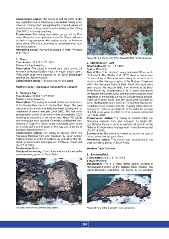
6. Sammy’s Bay the locality in the early 2000s and none were present on an
Coordinates: 30.489 S; 17.363 E inspection of the locality during the 2008 breeding season.
Status: Limited breeding Seals were again found, and 981 pups were counted, on
Description: This colony is located on the mainland south aerial photographs taken in 2014. The number of pups pro-
of the Spoeg River mouth in the Northern Cape. The area duced has since been increasing. Pupping takes place ex-
was previously mined and there has been subsequent re- clusively on rocky terrain adjacent to the water. An average
habilitation of closed mine pits (Beer 2012). The first aerial of 2,552 pups were counted on three surveys conducted
photographic survey of the colony was conducted in 2020 from 2014–2020.
following its discovery in the same year. About 760 adults Conservation status: The colony is situated within the
and three pups were counted. Consistent with habitat pref- Namaqua National Park and managed by South Afri-
erences of Cape Fur Seals, most individuals were found can National Parks in terms of sections 39 and 41 of the
on a rocky point at the south of the bay and a series of National Environmental Management: Protected Areas Act
boulders extending from it. (Act 57 of 2003).
Conservation status: The colony is situated within the Eco-tourism: The colony is visited by tourists as part of
Namaqua National Park and managed by South African the activities that the park offers.
National Parks in terms of sections 39 and 41 of the Na- Harvesting status: This colony was established in the
tional Environmental Management: Protected Areas Act post-harvesting period in South Africa.
(Act 57 of 2003).
Eco-tourism: None. Western Cape Colonies
History of harvesting: This colony was established in the
post-harvesting period in South Africa. 8. Elephant Rock
Coordinates: 31.640 S; 18.140 E
Status: Breeding
Description: This is a rocky island colony situated in
Namaqualand (north of the Olifants River mouth). The
island formation resembles the outline of an elephant
An aerial view of the Sammy’s Bay colony An aerial view of the Elephant Rock seal colony
297