
Page 308 - Atlas Sea Birds Ver1
P. 308
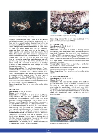
An aerial view of the Cape Point seal colony
                  An aerial view of the Duikerklip seal colony
                  munity  (Oosthuizen  and  David  1988). It  is  also  known   Harvesting status:  This colony was established  in the
                  as Duiker (cormorant) Island, but the locals simply call it   post-harvesting period in South Africa.
                  Seal Island. A vagrant Southern Elephant Seal (Mirounga
                  leonine) named “Buffel” visited the colony at least twice.   25. Partridge Point
                  Aerial surveys of this colony commenced  in 1984, when  Coordinates: 34.256 S; 18.481 E
                  11  pups and 4,628  adults were counted. However,   Status: Non-breeding.
                  seals and their pups were observed at the locality in   Description: This colony is situated on a  rocky  outcrop
                  1958,  together with breeding  Bank  Cormorants (Rand   off Partridge Point near Simon’s Town. It is also known as
                  1963).  The  eastern  side  of  the  colony  is protected from   Seal Rock. Seals were first observed in 1974 (Oosthuizen
                  extreme weather whereas the western side is  exposed.   and David 1988) and no pup production has been recorded
                  Storms  wash  pups  off  the  rocks  and  such  pups  often   to  date.  Oosthuizen  and  David  (1988)  reported  that  be-
                  land at the nearby coast. Pup production  was low (<80   tween 50 and 717 seals utilised the rocks between 1974
                  per  breeding  season)  in  the  1980s  (Oosthuizen  and     and 1986. During the 2020 aerial survey, 646 seals were
                  David  1988),  but    increased  in  the  2000s. An  average   counted in the colony.
                  of  625 pups were counted  on three surveys conducted   Conservation status:  There is currently no protection
                  between 2014 and 2020.                            for the rocks or waters around them.
                  Conservation status: The island was declared a Provin-   Eco-tourism:  Unregulated seal snorkel and swim-with
                  cial  Nature  Reserve  in terms of Section  6 of the Nature   activities are conducted at the rocks.
                  Conservation  Ordinance,  1974  (Official  Gazette  4524,   Harvesting status: There is no history of harvesting at this
                  1988). It is managed by Cape Nature with access restricted   colony.
                  to research activities under a permit. The waters around
                  the island are part of the Table Mountain National Park.  26. Seal Island, False Bay
                  Eco-tourism:  Boat-based seal viewing (Wickens et  al.   Coordinates: 34.136 S; 18.583 E
                  1991) and unregulated swim-with or snorkel-with seal tours  Status: Breeding
                  are conducted at the colony (Heidi 2020).         Description: This rocky island is situated in the northern
                  Harvesting status: There is no history of harvesting at this   part of, and has the largest of the three rookeries of Cape
                  colony.                                           Fur  Seals  in,  False  Bay  (Rand  1963).  Seabirds  have
                                                                    also bred at this island (Rand 1963, Shaughnessy 1984).
                  24. Cape Point                                    Competition for space and disturbance from seal harvest-
                  Coordinates: 34.356 S; 18.498 E                   ing operations reduced population sizes of some seabirds
                  Status: Limited breeding.                         (Rand 1951; Shelton et al. 1984). The island is now domi-
                  Description:  This colony is located on an east-facing,   nated by seals.
                  rocky  cliff  below  the  Cape  Point  Lighthouse.  It  was  dis-
                  covered and photographed for the first time in 2018, when
                  there were no seabirds breeding in its immediate vicinity.
                  However, around the point to the west, there was a colony
                  of Cape and White-breasted (P. lucidus) cormorants. Few
                  pups have been born thus far (4–6 p.a.) but there were 374
                  older seals in 2020. The terrain has a steep slope, which
                  may preclude vertical expansion  of the colony. However,
                  there is room for  an eastward  horizontal  expansion.
                  Conservation status:  The colony is situated within the
                  Table  Mountain National  Park that is managed  by the
                  South African National Parks in terms of Sections 39 and
                  41 of the National Environmental Management: Protected
                  Areas Act (Act 57 of 2003). Access is controlled.
                  Eco-tourism: The national park is a tourist attraction, but
                  no seal-targeted tourism is currently offered.    An aerial view of Partridge Point


                                                                 302