
Page 309 - Atlas Sea Birds Ver1
P. 309
Eco-tourism: Boat-based, eco-tourism tours are conduct-
ed around Dyer and Geyser islands.
Harvesting status: Harvesting ceased in 1984 (Wickens
et al. 1991).
29. Quoin Rock
Coordinates: 34.786 S; 19.668 E
Status: Breeding
Description: This rocky island is situated east of Quoin
An aerial view of the Seal Island, False Bay seal colony Point in the Bredasdorp district on the south coast. Pupping
Ecotourism: Regulated shark cage diving operations are was observed in the early 1900s, when seals displaced
a colony of Great White Pelicans (Rand 1963). Guano
conducted around the island and tourists are given a tour harvesting was conducted at this island. On average,
around the colony. Direct seal tourism has also been con-
ducted. 1,807 pups were born on four surveys from 2011–2014.
Harvesting status: Harvesting ceased in 1984 (Wickens Conservation status: The island was declared a
et al. 1991). Provincial Nature Reserve in terms of Section 6 of the
Nature Conservation Ordinance, 1974 (Official Gazette
4524, 1988). Access is restricted to researchers under a
27. Romans Bay permit. It is managed by Cape Nature.
Coordinates: 34.687 S; 19.408 E Eco-tourism: No eco-tourism is currently conducted at or
Status: Limited breeding around the colony.
Description: A bay on the north of Danger Point. Harvesting status: Harvesting ceased in 1984 (Wickens
A few pups were observed on rocks at the site in 2022. et al. 1991).
Conservation status: It is not protected.
30. Cape Infanta
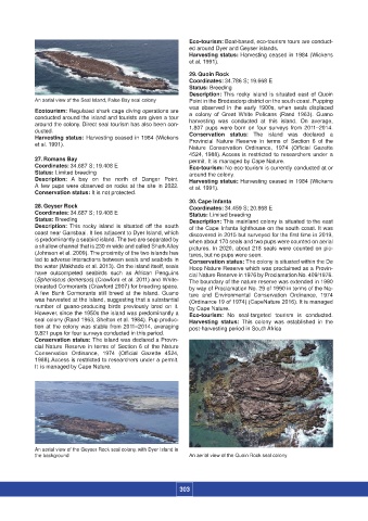
28. Geyser Rock Coordinates: 34.459 S; 20.868 E
Coordinates: 34.687 S; 19.408 E Status: Limited breeding
Status: Breeding Description: This mainland colony is situated to the east
Description: This rocky island is situated off the south of the Cape Infanta lighthouse on the south coast. It was
coast near Gansbaai. It lies adjacent to Dyer Island, which discovered in 2015 but surveyed for the first time in 2019,
is predominantly a seabird island. The two are separated by when about 170 seals and two pups were counted on aerial
a shallow channel that is 230 m wide and called Shark Alley pictures. In 2020, about 218 seals were counted on pic-
(Johnson et al. 2009). The proximity of the two islands has tures, but no pups were seen.
led to adverse interactions between seals and seabirds in Conservation status: The colony is situated within the De
the water (Makhado et al. 2013). On the island itself, seals Hoop Nature Reserve which was proclaimed as a Provin-
have outcompeted seabirds such as African Penguins cial Nature Reserve in 1976 by Proclamation No. 409/1976.
(Spheniscus demersus) (Crawford et al. 2011) and White- The boundary of the nature reserve was extended in 1990
breasted Cormorants (Crawford 2007) for breeding space. by way of Proclamation No. 29 of 1990 in terms of the Na-
A few Bank Cormorants still breed at the island. Guano ture and Environmental Conservation Ordinance, 1974
was harvested at the island, suggesting that a substantial (Ordinance 19 of 1974) (CapeNature 2016). It is managed
number of guano-producing birds previously bred on it. by Cape Nature.
However, since the 1950s the island was predominantly a Eco-tourism: No seal-targeted tourism is conducted.
seal colony (Rand 1963, Shelton et al. 1984). Pup produc- Harvesting status: This colony was established in the
tion at the colony was stable from 2011–2014, averaging post-harvesting period in South Africa
9,821 pups for four surveys conducted in this period.
Conservation status: The island was declared a Provin-
cial Nature Reserve in terms of Section 6 of the Nature
Conservation Ordinance, 1974 (Official Gazette 4524,
1988). Access is restricted to researchers under a permit.
It is managed by Cape Nature.
An aerial view of the Geyser Rock seal colony, with Dyer Island in
the background An aerial view of the Quoin Rock seal colony
303