
Page 450 - NGTU_paper_withoutVideo
P. 450
Modern Geomatics Technologies and Applications
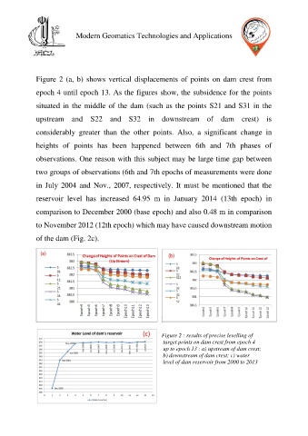
Figure 2 (a, b) shows vertical displacements of points on dam crest from
epoch 4 until epoch 13. As the figures show, the subsidence for the points
situated in the middle of the dam (such as the points S21 and S31 in the
upstream and S22 and S32 in downstream of dam crest) is
considerably greater than the other points. Also, a significant change in
heights of points has been happened between 6th and 7th phases of
observations. One reason with this subject may be large time gap between
two groups of observations (6th and 7th epochs of measurements were done
in July 2004 and Nov., 2007, respectively. It must be mentioned that the
reservoir level has increased 64.95 m in January 2014 (13th epoch) in
comparison to December 2000 (base epoch) and also 0.48 m in comparison
to November 2012 (12th epoch) which may have caused downstream motion
of the dam (Fig. 2c).
(c) Figure 2 : results of precise levelling of
target points on dam crest from epoch 4
up to epoch 13 : a) upstream of dam crest;
b) downstream of dam crest; c) water
level of dam reservoir from 2000 to 2013