
Page 100 - Авторлық бағдарлама. Алденова Фарида
P. 100
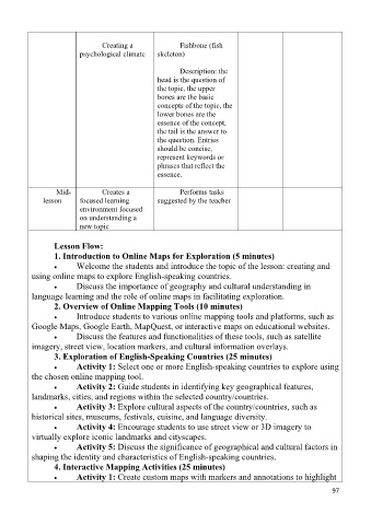
Creating a Fishbone (fish
psychological climate skeleton)
Description: the
head is the question of
the topic, the upper
bones are the basic
concepts of the topic, the
lower bones are the
essence of the concept,
the tail is the answer to
the question. Entries
should be concise,
represent keywords or
phrases that reflect the
essence.
Mid- Creates a Performs tasks
lesson focused learning suggested by the teacher
environment focused
on understanding a
new topic
Lesson Flow:
1. Introduction to Online Maps for Exploration (5 minutes)
Welcome the students and introduce the topic of the lesson: creating and
using online maps to explore English-speaking countries.
Discuss the importance of geography and cultural understanding in
language learning and the role of online maps in facilitating exploration.
2. Overview of Online Mapping Tools (10 minutes)
Introduce students to various online mapping tools and platforms, such as
Google Maps, Google Earth, MapQuest, or interactive maps on educational websites.
Discuss the features and functionalities of these tools, such as satellite
imagery, street view, location markers, and cultural information overlays.
3. Exploration of English-Speaking Countries (25 minutes)
Activity 1: Select one or more English-speaking countries to explore using
the chosen online mapping tool.
Activity 2: Guide students in identifying key geographical features,
landmarks, cities, and regions within the selected country/countries.
Activity 3: Explore cultural aspects of the country/countries, such as
historical sites, museums, festivals, cuisine, and language diversity.
Activity 4: Encourage students to use street view or 3D imagery to
virtually explore iconic landmarks and cityscapes.
Activity 5: Discuss the significance of geographical and cultural factors in
shaping the identity and characteristics of English-speaking countries.
4. Interactive Mapping Activities (25 minutes)
Activity 1: Create custom maps with markers and annotations to highlight
ϵϳ