
Page 289 - Thai Heritage from Space_ebook
P. 289
ดงพญาเย็น เส้นทางผ่านจากอ่าวไทยสู่ที่ราบสูงโคราช 15 ํ 35’ N
102 ํ 39’ E
ศรีเทพ
พิมาย
ซับจําปา
เสมา
โคราช
ปากช่อง
ถนนมิตรภาพ
ลําตะคอง
สระบุรี
อู่ตะเภา
N
14 km.
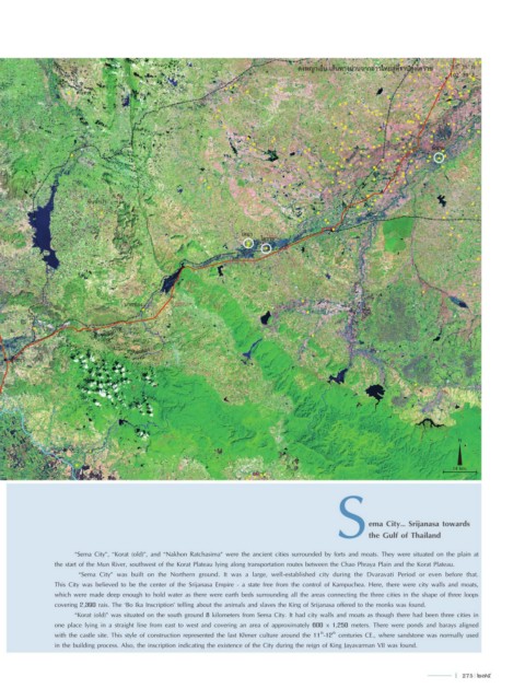
ema City… Srijanasa towards
the Gulf of Thailand
“Sema City”, “Korat (old)”, and “Nakhon Ratchasima” were the ancient cities surrounded by forts and moats. They were situated on the plain at
the start of the Mun River, southwest of the Korat Plateau lying along transportation routes between the Chao Phraya Plain and the Korat Plateau.
“Sema City” was built on the Northern ground. It was a large, well-established city during the Dvaravati Period or even before that.
This City was believed to be the center of the Srijanasa Empire - a state free from the control of Kampuchea. Here, there were city walls and moats,
which were made deep enough to hold water as there were earth beds surrounding all the areas connecting the three cities in the shape of three loops
covering 2,390 rais. The ‘Bo Ika Inscription’ telling about the animals and slaves the King of Srijanasa offered to the monks was found.
“Korat (old)” was situated on the south ground 8 kilometers from Sema City. It had city walls and moats as though there had been three cities in
one place lying in a straight line from east to west and covering an area of approximately 600 x 1,250 meters. There were ponds and barays aligned
with the castle site. This style of construction represented the last Khmer culture around the 11 -12 centuries CE., where sandstone was normally used
th
th
in the building process. Also, the inscription indicating the existence of the City during the reign of King Jayavarman VII was found.
l 275 275