
Page 315 - Thai Heritage from Space_ebook
P. 315
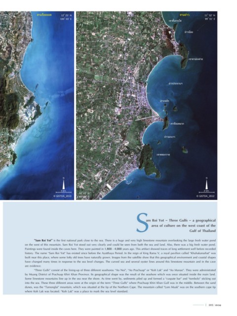
สามร้อยยอด    12 ํ 23’ N                                                               สามอ่าว        11 ํ 52’ N
                                      100 ํ 03’ E                                                                              99 ํ 51’ E
                                                                                                         เขาคั่นกระได


                                                                                                                  อ่าวน้อย


                                                                                                                     เขาตาม่องล่าย


                                                                                                        อ่าวประจวบฯ


                                                                                                   เกาะหลัก


                                                                                                         เขาล้อมหมวก


                                                                                                      อ่าวมะนาว


                                                                                                 เขาคลองวาฬ


                                       N                                                                                       N


                                      5 km.                                                                                   2 km.
                                                 11 ํ 43’ N
                                  © GISTDA_2010  99 ํ 44’ E                                                              © GISTDA_2012
                                                                                    S         area of culture on the west coast of the


                                                                                          am Roi Yot - Three Gulfs - a geographical


                                                                                                                     Gulf of Thailand


                      “Sam Roi Yot” is the first national park close to the sea. There is a huge and very high limestone mountain overlooking the large fresh water pond
                on the west of this mountain. Sam Roi Yot stood out very clearly and could be seen from both the sea and land. Also, there was a big fresh water pond.
                Paintings were found inside the caves here. They were painted in 1,800 - 4,000 years ago. This artifact showed traces of long settlement well before recorded
                history. The name “Sam Roi Yot” has existed since before the Ayutthaya Period. In the reign of King Rama V, a royal pavilion called “Khuhakaruehat” was
                built near this place, where some lofty old trees have naturally grown. Images from the satellite show that this geographical environment and coastal shapes
                have changed many times in response to the sea level changes. The curved sea and several oyster lines around this limestone mountain and in the cave
                are evidence.
                      “Three Gulfs” consist of the lining-up of three different seashores: “Ao Noi”, “Ao Prachuap” or “Koh Lak” and “Ao Manao”. They were administrated
                by Muang District of Prachuap Khiri Khan Province. Its geographical shape was the result of the seashore which was once situated inside the main land.
                Some limestone mountains line up in the sea near the shore. As time went by, sediments piled up and formed a “cuspate bar” and “tombolo” sticking out
                into the sea. These three different areas were at the origin of the term “Three Gulfs” where Prachuap Khiri Khan Gulf was in the middle. Between the sand
                dunes, was the “Tamonglai” mountain, which was situated at the tip of the Northern Cape. The mountain called “Lom Muak” was on the southern cape tip
                where Koh Lak was located. “Koh Lak” was a place to mark the sea level standard.


                                                                                                                               l  301  301