
Page 231 - Art In The Age Of Exploration (Great Section on Chinese Art Ming Dynasty)
P. 231
±31
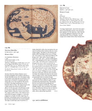
Juan de la Cosa
Spanish, c. 1450/1460-1510
WORLD CHART
1500
parchment
3
960 x 1830 (37 /2 x 72)
references: Vascdno 1892; Morison 1942, 1:186-
188; Skelton 1958, 71; Ganong 1964, 8-43, 469-
473; Morison 1974, 139-140; Parry 1979, 113-114;
Campbell 1982, p. 14-15; Nebenzahl 1990, 30-33
Museo Naval, Madrid
This large mappamundi —one of the most impor-
tant of all cartographic records of the early Euro-
pean exploration of the Americas—bears the date
1500 and the signature of Juan de la Cosa, who
sailed aboard the Nina on Columbus' second
voyage (some scholars believe that the Juan de la
129
Henricus Martellus clearly identified, while a few inscriptions the east
Africa testify to the
recent
most
coast of southern
German, active c. 1480-1496 coastal voyages. The names on the African coast
WORLD MAP clearly reflect knowledge of the travels of Diogo
Cao — his voyage as far as Cape Santa Maria in the
from Insularium illustratum Kongo (1482-1484) and his second voyage, to
c. 1489 Cape Cross (1485-1487) —and also of Bartolomeu
manuscript on vellum, 75 fols. Dias' circumnavigation of the Cape of Good Hope
4
30 x 47 (ii /sx iSVz) (1487-1488). The farthest point reached by Dias,
references: Almagia 1940; London 1960, 19, no. 28, the great Fish River, is duly recorded (ilha de
pi. ma; Bagrow and Skelton 1964, 81-82, pi. mi;
Destombes 1964, 230-232; Hamann 1968; Klemp fonti). An inscription next to the Kongo mentions
1968, no. 7; Campbell 1987, 72-74, 77-78, 213 the commemorative stone (Padrao) Cao erected at
Cape Negro during his second voyage (Hamann
The British Library Board, London, MS Add. 15760, 1968, 195-199, fig. 15). Other sections of the map
fols. 6817-69r are not as accurate. Madagascar is not recorded,
and Asia is still poorly depicted, while Scandina-
Henricus Martellus (Henry Hammer) was a via follows the configuration found in the second
German cartographer who worked in Florence in map of Claudius Calvus, with Greenland depicted
the late fifteenth century. He is best known today as a peninsula linked to northern Europe.
as the author of the maps that are included in two The world maps of Martellus have often been
manuscripts of Ptolemy's Geography and three associated with Martin Behaim's globe of 1492
manuscripts of his own Insularium illustratum, (Germanisches Nationalmuseum, Nuremberg);
as well as of the large world map now in the both are non-Ptolemaic but graduated with
Beinecke Library at Yale. The mappamundi in the degrees for longitude and latitude. (The present
London manuscript of the Insularium still example, however, does not include such gradua-
adheres for the most part to the Ptolemaic model tions. ) The differences between the two, however,
for the eastern half of the world, but Asia is no especially in their mapping of southern Africa,
longer linked to Africa by a narrow strip of land. make a direct relationship improbable. J.M.M.
The southern half of Africa, which had just been
explored by Portuguese navigators, is somewhat
exaggerated in length, literally outgrowing the
boundary of the known world, as its southern tip
had now been reached and even circumnavigated.
The Cape of Good Hope (capo d'esperanza) is 130 not in exhibition
230 CIRCA 1492