
Page 232 - Art In The Age Of Exploration (Great Section on Chinese Art Ming Dynasty)
P. 232
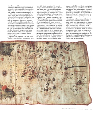
Cosa who is recorded  as the  master-owner  of the  sents  de la Cosa's recantation  of the  coerced  signature  read Xpb  Ferens ("Christ bearing")  and
              Santa  Maria on the  first  voyage was a  different  pledge is unclear. It has been suggested that  the  who increasingly saw himself in the  role of carry-
              person).  In a celebrated incident that occurred on  map, though  dated  1500,  was completed some  ing the  divine word to foreign lands. The Virgin
              12 June 1494  off the  southern  coast of Cuba, de la  years later.  Some scholars believe that  the map is  and Child are also depicted on the  map, in  the
              Cosa, together with all the other members  of the  an early  copy of the  lost  original  of 1500.  Juan de  wind  rose just to the  left  of the designation  Mare
              expedition, signed a document prepared by Co-  la Cosa himself participated in three  expeditions  Oceanum  (Ocean Sea), another reference to  the
              lumbus stating that  Cuba was part of a continent.  to the  Caribbean coast of South America and was  missionary character of Spanish sponsorship of
              Columbus had been sailing west and was less than  killed in  1510  by a poisoned arrow during a slave  the  voyages.
              fifty  miles  from rounding  Cuba's  southwestern  raid in Cartagena  Bay, in what  is now  Colombia.  As is the case with  the  Catalan Atlas (cat. i),
              edge, but he decided at that point to turn back,  His impressive map grapples with  the  problem  some of the  inscriptions on de la Cosa's map
              evidently  satisfied that  Cuba was indeed part of  of representing  the  newly-known  territories  appear upside-down or at an angle of 90°,  suggest-
                                         7
              the  so-called  "Golden  Chersonese/  the elongated  within  the  framework of the traditional portolan  ing that  it was meant to be placed on a table and
              peninsula  at the  southeastern  end of Asia that was  mappamundi.  It is unclear whether the  contours  looked  at from all sides. Although de la Cosa
              represented on European maps of the  period (see  of the  mainland that extend north  and south of  includes information based on the  latest  voyages
              cat.  129).  He pressured his crew into  supporting  the  Caribbean are meant to be seen as an  exten-  to Africa,  India, and the  New World, the depiction
              this idea, which would have proven that  he was  sion of Asia, which runs off the  map at the  right.  of the  eastern  regions of Asia has changed little
              close to the realms  of the  Chinese  emperor,  but  It is not even  certain whether they are thought to  from  the time  of the  Catalan Atlas, and the fig-
              his assertion was quickly challenged when  he  be connected to each other —a representation of  ures at the upper right  corner of the map are still
              returned to Spain.                          Saint Christopher  bearing the  Christ  child covers  the legendary Gog and Magog (see Massing essay
                Juan de la Cosa's map shows Cuba as an island.  the  area to the west of the  Caribbean. This pre-  "Observations and Beliefs:  The World of the
              Whether it depends on later  information  or  repre-  sumably  is meant  to refer to Columbus,  whose  Catalan Atlas"  in this catalogue).


                                                                                                EUROPE  AND THE  MEDITERRANEAN  WORLD    23!