
Page 234 - Art In The Age Of Exploration (Great Section on Chinese Art Ming Dynasty)
P. 234
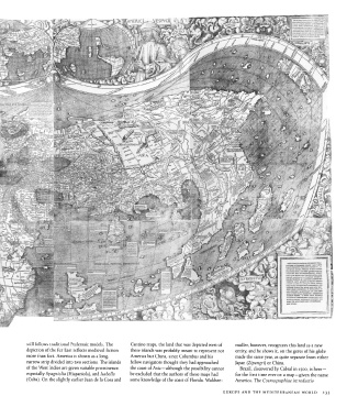
still  follows traditional  Ptolemaic models.  The  Cantino maps, the  land that was depicted west of  miiller, however,  recognizes this land as a new
               depiction of the  Far East reflects medieval  fiction  these islands was probably meant  to represent  not  entity, and he shows it, on the  gores of his globe
               more than  fact.  America is shown  as a long,  America but  China, since Columbus and his  made the  same year, as quite separate from  either
               narrow strip divided into two sections.  The islands  fellow navigators thought they had approached  Japan  (Zipangri)  or  China.
               of the  West  Indies are given  suitable prominence,  the  coast of Asia — although  the  possibility cannot  Brazil, discovered by  Cabral in  1500,  is here —
               especially Spagniolia  (Hispaniola), and Isabella  be excluded that the authors of these maps had  for  the  first  time  ever on a map — given the  name
               (Cuba).  On  the  slightly earlier Juan de la Cosa and  some knowledge of the  coast of Florida.  Waldsee-  America.  The Cosmographiae  introductio


                                                                                                EUROPE  AND  THE  MEDITERRANEAN  WORLD    233