
Page 233 - Art In The Age Of Exploration (Great Section on Chinese Art Ming Dynasty)
P. 233
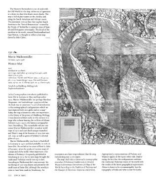
The Western  Hemisphere is out  of scale with
          the  Old World on the  map, either out of ignorance
          or a desire to show the  details more  clearly.  The
          map is full  of place names in the  Antilles  and
          along the  South American and African  coasts.
          The prominent vertical line that touches  South
          America  is the  "line of demarcation"  created by
          the  Treaty  of Tordesillas to  separate areas of Span-
          ish and Portuguese  sovereignty.  The detail  of the
          coastline to the north, around Newfoundland and
          Cape Breton, is thought  to reflect  a lost map
          drawn by John Cabot.               j. A.L.


           1 3 2
          Martin  Waldseemiiller
          German, 1470-1518
          WORLD    MAP

          1507
          woodcut  on  12 sheets
          120 x 240, each sheet 45 x  60 (4^/4  x 9 4^2, each
                3
          sheet  i7 /4 x  23%)
          references:  Fischer and  Wieser  1903, 1-18, 45-55,
          pis. 1-13;  Laubenberger  1959;  Fite and Freeman
          1969, 24-27,  no. 8; Klemp  1976,  no. 4;  Harris 1985

          Furstlich zu  Waldburg-Wolfegg'sche
          Kupferstichkabinett

          In his  Cosmographiae  introductio  published in
          Saint-Die in Lorraine in May and  September
          1507,  Martin  Waldseemiiller  (or perhaps  Matthias
          Ringmann: see Laubenberger 1959)  noted  that
          the book was to constitute  "a sort  of  introduction
          to the cosmographical configurations which we
          have depicted both  on a globe and on a map/'
          Today the  map is known in only one impression,
          in the  library of the  prince of Waldburg-Wolf egg.
          It was discovered there  early in this century in a
          large folio volume bearing the  ex libris of Johann
          Schoner  (1477-1557), the famous cartographer
          from  Nuremberg.  This remarkable volume  con-
          tained  Martin  Waldseemiiller's woodcut  world
          maps of  1507  and  1516  (both unique examples)
          and Diirer's map of the  heavens of  1515  (see cats.
          118,119), as well as gores of Schoner's celestial
          globe of  1517.
            Martin Waldseemiiller was born in  Radolfzell
          in Germany in  1470  and died probably in  1518,  in
          Saint-Die.  He settled at the court of Rene n, duke
          of Lorraine, where  he produced various maps of
          Europe and of the world.  Most important  is his
          edition of Ptolemy's Geography published in  inscription on a later map indicates that  the  orig-  Appropriately, representations  of Ptolemy  and
          Strasbourg  in  1513,  for its new maps brought  the  inal printing  was 1,000  copies.  Vespucci appear at the top at either side,  empha-
          traditional Ptolemaic world view up to date.  The map's full  title  is  Universalis  cosmographia  sizing the  fact that  the configuration combines
          According to Waldseemiiller's own account, his  secundum  Ptholomaei  traditionem et Amend  the traditional Ptolemaic vision of the world  with
          world map of 1507  was drawn and printed in  the  Vespucii  aliorumque  lustrationes  (A  Map  of  the  the  results of the  latest  geographical explorations.
          small town  of Saint-Die,  although  the  woodcuts  World  According  to  the  Tradition  of Ptolemy  and  Africa  is shown to be circumnavigable, but  the
          seem to have been made in Strasbourg.  An   the  Voyages  of Americus  Vespucius  and  others).  topography of India and what is now Sri Lanka

          232   CIRCA  1492