
Page 236 - Art In The Age Of Exploration (Great Section on Chinese Art Ming Dynasty)
P. 236
one image, Rosselli had to determine the relation-
ship between the lands described by Columbus,
Vespucci, and Cabot and the traditional image of
Asia. Newfoundland appears at the upper left, as
the easternmost limit of Asia. The West Indies are
below, with Cuba shown as an island, and below
that is a South American continent, labeled
Mundus Novus. In his Fourth Voyage of 1502-
1503, Columbus had explored the coast of Central
America, designating many place names. These
appear in Rosselli's map at the lower right, along
the southeast Asian coast. The island at the
extreme right edge of the map is Japan.
This map is known in only two other impres-
sions, one in the Biblioteca Nazionale Centrale,
Florence, and a hand-colored example in the
National Maritime Museum, Greenwich, which
was long thought to be a manuscript map rather
than an engraved one. J.A.L.
*34
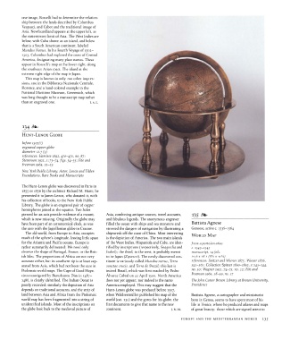
HUNT-LENOX GLOBE
before 1507(7]
engraved copper globe
diameter 12.7 (5)
references: Harrisse 1892, 470-471, no. 87;
Stevenson 1921, 1:73-74, figs. 34-35; Fite and
Freeman 1969, 22-23
New York Public Library, Astor, Lenox and Tilden
Foundations, Rare Books and Manuscripts
The Hunt-Lenox globe was discovered in Paris in
1855 or 1856 by the architect Richard M. Hunt; he
presented it to James Lenox, who donated it, with
his collection of books, to the New York Public
Library. The globe is an engraved pair of copper
hemispheres joined at the equator. Two holes
pierced for an axis provide evidence of a mount, Asia, combining antique sources, travel accounts, *35
which is now missing. Originally the globe may and fabulous legends. The anonymous engraver
have been part of an astronomical clock, as was filled the ocean with ships and sea monsters and Battista Agnese
the case with the Jagiellonian globe in Cracow. stressed the dangers of navigation by illustrating a Genoese, active c. 1536-1564
The old world, from Europe to Asia, occupies shipwreck off the coast of China. Most interesting WORLD MAP
much of the sphere's longitude, leaving little space is the depiction of America. The two main islands
for the Atlantic and Pacific oceans. Europe is of the West Indies, Hispaniola and Cuba, are iden- from a portolan atlas
rather summarily delineated: We need only tified by inscriptions (respectively, Spagnolia and c. 1543-1545
observe the shape of Portugal, France, or the Brit- Isabel); the third, to the west, is probably meant manuscript, 14 fols.
ish Isles. The proportions of Africa are not very to be Japan (Zipancri). The newly discovered con- 21.6x28.2 (SVzxuVs)
accurate either, but its southern tip is at least sep- tinent is variously called Mundus novus, Terra references: Spitzer and Wiener 1875; Wieser 1876,
arated from Asia, which had not been the case in sanctae crucis, and Terra de Brazil, this last is 541-561; Collection Spitzer 1890-1892, 5:143-144,
Ptolemaic world maps. The Cape of Good Hope, indeed Brazil, which was first reached by Pedro no. 30; Wagner 1931, 74-75, no. 32; Fite and
circumnavigated by Bartolomeu Dias in 1487- Alvarez Cabral on 22 April 1500. North America Freeman 1969, 58-59, no. 17
1488, is clearly identified. The Indian Ocean is does not yet appear; nor indeed is the name The John Carter Brown Library at Brown University,
poorly recorded; similarly the depiction of Asia America employed. This may suggest that the Providence
depends on traditional accounts, and the strip of Hunt-Lenox globe was produced before 1507,
land between Asia and Africa from the Ptolemaic when Waldseemiiller published his map of the Battista Agnese, a cartographer and miniaturist
world map has been fragmented into a string of world (cat. 132) and the gores for his globe, the born in Genoa, seems to have spent most of his
unidentified islands. Most of the inscriptions on first documents to give that name to the new life in Venice, where he produced atlases and maps
the globe look back to the medieval picture of continent. J.M.M. of great beauty; those which are signed attest to
EUROPE AND THE MEDITERRANEAN WORLD 235