
Page 237 - Art In The Age Of Exploration (Great Section on Chinese Art Ming Dynasty)
P. 237
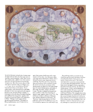
his activity between  1536  and  1564.  In many  ways  gust).  Next  comes  a double page with a  repre-  The world map itself is surrounded  by  the
       his maps recall sea charts, but they seem  never to  sentation  of the  zodiac, then  declination tables,  winds blowing from  twelve directions, with  four
       have been used in navigation:  rather,  they  convey,  and a page with  an illustration  of Jupiter. This is  personifications  (Faith, Charity,  Justice, and
       like a modern  atlas,  a global vision  of the  world as  followed by eleven  maps, beginning  with the  another  Virtue) at the corners.  The world is
       seen from  a European perspective and  through  world map.  The others  represent,  respectively,  superimposed on a projection constructed  with
       European eyes.  More than  seventy  atlases by Bat-  Spain and northwest  Africa,  northwest  Europe,  curved meridians and straight  parallels. There are
       tista Agnese  are known  today  (see Wagner  1931,  the western  and then the central part of the  large areas of unmapped territory,  especially to
       1-110;  1947,  28-30), two of them  in the John  Mediterranean, the  Black Sea, the Greek archipe-  the  north  of Asia and America.  The shape of the
       Carter  Brown Library in Providence.  The so-  lago, the  eastern  Mediterranean, and finally, in  Mediterranean, of Africa,  and  of Madagascar is
       called Charles v atlas exhibited  here is splendidly  three maps, the  Indian, Atlantic, and  Pacific  more or less accurate, but  as in so many  other
       decorated. In fact it was made not  for the  emperor  Oceans.  The atlas is undated but internal evid-  maps of this period Asia still depends on  the
       but  for his son, the  future  Philip n of Spain. A  ence, as well as a study  of the  chronology of  world map of Ptolemy  The triangular  form  of  the
       frontispiece  to the  atlas shows Providence handing  Agnese's  maps, suggests  a date of 1543-1545.  The  Indian subcontinent  is not understood;  the island
       over a globe to the young  prince, together  with  world map is of the  so called post-Californian  that  is now Sri Lanka  (Taprobana)  is still far too
       the  arms of Castile and Aragon,  and a dedication  type, showing  California  as a peninsula.  This  large;  and China  and the  Malaysian  peninsula  are
       to Philip:  "Philippe Caroli Aug[usti]  F[ilio]  "discovery/' made during  Francisco de Ulloa's  drawn without  any direct knowledge of their  con-
       Optimo princ[ipi] Providentia" (Providence to  exploration of the  Gulf  of California  in  1539,  was  figuration.  America is depicted with more accu-
       Philip,  excellent  prince,  son of Charles  the  Au-  first included by Agnese  in his world map of  1542.  racy, although  it is connected  to the west with

       236   CIRCA  1492