
Page 1179 - Chief Architect Reference Manual
P. 1179
Chief Architect X10 Reference Manual
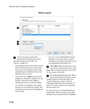
Select Layers
1 A list of the layers found in the • If a layer is set to Convert To a Terrain
imported file and information about Perimeter or Elevation Data, it will be
each layer displays in this table. See indicated in this column provided that you
“Layers” on page 184. are importing into floor plan view.
•In the Layer column, check the box to the Click Select All to check the box to the
left of each layer name to specify which 2 left of all layer names in the table. Click
layers you want to import. Layers with Clear All to clear the checkbox to the left of
checked boxes are imported; those with all layer names in the table.
unchecked boxes are not.
• Layers that were Visible in the original 3 The Convert To drop-down list allows
you convert the data on any layer into a
program are checked by default. You can Terrain Perimeter or Elevation Data. See
include a layer that is not visible by “Terrain Perimeter” on page 1202 and
checking the box to the left of its name. “Importing DXF/DWG Elevation Data” on
• Layers that were Frozen in the original page 1239. Only available when importing
program are not checked by default. You into floor plan view.
can include a frozen layer by checking the To convert a layer to a Terrain Perimeter or
box to its left.
Terrain Data, click on its name in the table
and then select an option from the Convert
1178