
Page 9 - Swale AQMA Feasibility Study April 2020_
P. 9
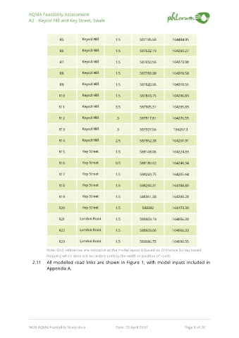
AQMA Feasibility Assessment
               A2 – Keycol Hill and Key Street, Swale


                               R5         Keycol Hill      1.5         587195.69       164484.95

                               R6         Keycol Hill      1.5         587632.19       164360.27

                               R7         Keycol Hill      1.5         587650.56       164373.98


                               R8         Keycol Hill      1.5         587783.38       164319.58


                               R9         Keycol Hill      1.5         587820.06       164318.56

                              R10         Keycol Hill      1.5         587843.75       164296.83

                              R11         Keycol Hill      3.5         587905.31       164295.83


                              R12         Keycol Hill      3           587917.81       164276.55


                              R13         Keycol Hill      3           587937.56       164267.3

                              R14         Keycol Hill      2.5         587952.38       164251.91

                              R15         Key Street       1.5         588148.06       164224.83


                              R16         Key Street       0.5         588180.62       164246.34


                              R17         Key Street       1.5         588243.75       164205.64

                              R18         Key Street       1.5         588290.31       164188.89

                              R19         Key Street       1.5         588351.38       164200.28


                              R20         Key Street       1.5          588382         164173.39


                              R21        London Road       1.5         588903.19       164056.38

                              R22        London Road       1.5         588929.06       164066.33

                              R23        London Road       1.5         589086.75       164030.55

                        Note: Grid references are indicative as the model layout is based on Ordnance Survey based
                        mapping which does not accurately portray the width or position of roads.
                 2.11   All modelled road links are shown in Figure  1, with model inputs included in
                        Appendix A.


               9438 AQMA Feasibility Study.docx            Date: 20 April 2020                     Page 8 of 20