
Page 271 - Thai Heritage from Space_ebook
P. 271
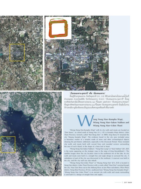
เวียงหนองหาน-อุดรธานี (2-1)         17 ํ 25’ N                                                       หนองหาน (2-2)
                                     103 ํ 08’ E                                             อ�ำเภอหนองหำน จังหวัดอุดรธำนี


                                      N                                                                   N


                                     1 km.                                                              400 m.
 17 ํ 18’ N                                     17 ํ 21’ N
 103 ํ03’ E                      © GISTDA_2014  103 ํ05’ E                                          © GISTDA_2014


 เวียงหนองหาน-สกลนคร (3-2)                              17 ํ 17’ N       “เวียงหนองหาน-อุดรธานี” หรือ “เมืองหนองหาน”
                                                        104 ํ 16’ E      ตั้งอยู่ที่อ�าเภอหนองหาน จังหวัดอุดรธานี (2-1, 2-2) มีห้วยด่านไหลผ่านไปออกแม่น�้าโขงที่
                                                                   ต�าบลจุมพล  อ�าเภอโพนพิสัย  จังหวัดหนองคาย  ห่างจาก  “เวียงหนองหาน-กุมภวาปี”  ตั้งอยู่
                                                                   ทางทิศตะวันตกเฉียงใต้ระยะทางประมาณ ๒๗ กิโลเมตร และห่างจาก “เวียงหนองหาน-สกลนคร”
                                                                   ตั้งอยู่ทางทิศตะวันออกระยะทางประมาณ ๑๑๔ กิโลเมตร “เวียงหนองหาน-อุดรธานี” เป็นเมืองโบราณ
                                                                                W
                                                                   มีก�าแพงเมือง-คูเมืองล้อมรอบเป็นรูปแบบเส้นตรงมุมเหลี่ยมสร้างขึ้นภายหลัง


                                                                                                 iang Nong Han-Kumpha Wapi,
                                                                                                 Wiang Nong Han-Sakon Nakhon and
                                                                                                 Wiang Nong Han-Udon Thani

                                                                         “Wiang Nong Han-Kumpha Wapi” with its city walls and moats are located on
                                                                   “Don Kaew”, an island south of Nong Han (1-1, 1-2) in Kumpha Wapi district, Udon
                                                                   Thani Province, formerly called “Ban Bung Mor”. In 1872, King Rama IV renamed the
                                                                   city “Muang Kumpha Wapi”. The evidence found in the city area included sema
                                                                   (a boundary marker of a temple) made of stone and other archaeological objects
                                                                   showing the pre-historic settlement, especially in the Dvaravati Period. These included
                                                                   city walls and moats built with curved lines and rounded corners surrounding
                                                                   the area of each island, in the shape of a lotus leaf or heart.
                                                                         “Wiang Nong Han-Sakon Nakhon”, “Nong Han Luang” or “Kula Nakhon” (3-1, 3-2)
                                                                   is the name appearing on the strategic map in the reign of King Ramathibodi I. The
                                                                   satellite images show the city location close to the southwest rim of the lake. Its city
                                                                   walls and moats were built in a straight line and angle design to surround the city. A
                                                                   subsidence of part of the city was discovered in the northeast. A reservoir was built in
                                                                   the city, and the city wall was also rebuilt.
                                                          N              “Wiang Nong Han-Udon Thani” or “Muang Nong Han” (2-1, 2-2) is located in
                                                                   Nong Han district, Udon Thani Province with a creek called “Huai Dan” running through
                                                                   the city. Huai Dan flows out to the Mekong River at Jum Phon sub-district, Phon Phisai
                                                                   district, Nong Khai Province, 21 km. southwest from “Wiang Nong Han Kumpha Wapi”.
                                                         3 km.
 17 ํ 05’ N                                                        “Wiang Nong Han Udon Thani” is an ancient city with walls and moats surrounding
 104 ํ 06’ E                                        © GISTDA_2012  it and built in a design of straight lines and angles.


                                                                                                                               l  257  257