
Page 273 - Thai Heritage from Space_ebook
P. 273
16 ํ 34’ N
104 ํ 32’ E
ลําเสียวใหญ่
ร้อยเอ็ด ลําเสียว แม่นํ้าชี
มหาสารคาม ลําพลับพลา ยโสธร
ศรีสะเกษ
สุรินทร์
N
10 km.
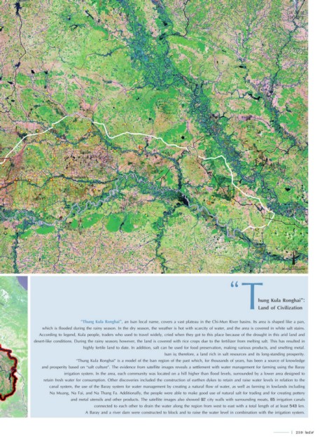
hung Kula Ronghai”:
Land of Civilization
“Thung Kula Ronghai”, an Isan local name, covers a vast plateau in the Chi-Mun River basins. Its area is shaped like a pan,
which is flooded during the rainy season. In the dry season, the weather is hot with scarcity of water, and the area is covered in white salt stains.
According to legend, Kula people, traders who used to travel widely, cried when they got to this place because of the drought in this arid land and
desert-like conditions. During the rainy season; however, the land is covered with rice crops due to the fertilizer from melting salt. This has resulted in
highly fertile land to date. In addition, salt can be used for food preservation, making various products, and smelting metal.
Isan is; therefore, a land rich in salt resources and its long-standing prosperity.
“Thung Kula Ronghai” is a model of the Isan region of the past which, for thousands of years, has been a source of knowledge
and prosperity based on “salt culture”. The evidence from satellite images reveals a settlement with water management for farming using the Baray
irrigation system. In the area, each community was located on a hill higher than flood levels, surrounded by a lower area designed to
retain fresh water for consumption. Other discoveries included the construction of earthen dykes to retain and raise water levels in relation to the
canal system, the use of the Baray system for water management by creating a natural flow of water, as well as farming in lowlands including
Na Muang, Na Fai, and Na Thang Fa. Additionally, the people were able to make good use of natural salt for trading and for creating pottery
and metal utensils and other products. The satellite images also showed 92 city walls with surrounding moats, 65 irrigation canals
connected to each other to drain the water along the region from west to east with a total length of at least 543 km.
A Baray and a river dam were constructed to block and to raise the water level in combination with the irrigation system.
l 259 259