
Page 17 - Legal Aid CRP EJ Toolkit
P. 17
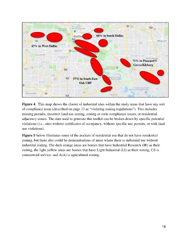
60% in South Dallas


                      43% in West Dallas


                                                                                       71% in Pleasant
                                                                                        Grove/Kleberg


                                                 57% in South East
                                                     Oak Cliff


               Figure 4.  This map shows the cluster of industrial sites within the study areas that have any sort
               of compliance issue (described on page 13 as “violating zoning regulations”). This includes
               missing permits, incorrect land use zoning, zoning or code compliance issues, or residential
               adjacency issues. The data used to generate this toolkit can be broken down by specific potential
               violations (i.e., sites without certificates of occupancy, without specific use permits, or with land
               use violations).

               Figure 5 below illustrates some of the pockets of residential use that do not have residential
               zoning, but there also could be demonstrations of areas where there is industrial use without
               industrial zoning. The dark orange areas are homes that have Industrial Research (IR) as their
               zoning, the light yellow areas are homes that have Light Industrial (LI) as their zoning, CS is
               commercial service, and A(A) is agricultural zoning.


                                                                                                           16