
Page 26 - manual_V5_11_9_2018_Html5
P. 26
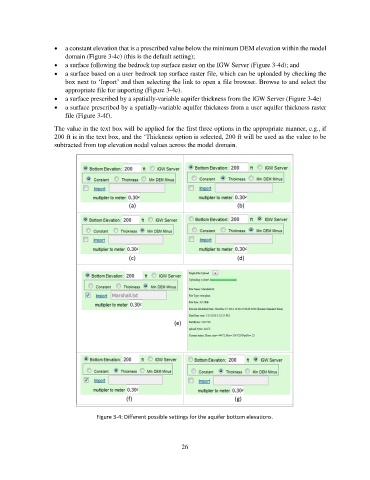
•  a constant elevation that is a prescribed value below the minimum DEM elevation within the model
                       domain (Figure 3-4c) (this is the default setting);
                   •  a surface following the bedrock top surface raster on the IGW Server (Figure 3-4d); and
                   •  a surface based on a user bedrock top surface raster file, which can be uploaded by checking the
                       box next to ‘Inport’ and then selecting the link to open a file browser. Browse to and select the
                       appropriate file for importing (Figure 3-4e).
                   •  a surface prescribed by a spatially-variable aquifer thickness from the IGW Server (Figure 3-4e)
                   •  a surface prescribed by a spatially-variable aquifer thickness from a user aquifer thickness raster
                       file (Figure 3-4f).

                   The value in the text box will be applied for the first three options in the appropriate manner, e.g., if
                   200 ft is in the text box, and the ‘Thickness option is selected, 200 ft will be used as the value to be
                   subtracted from top elevation nodal values across the model domain.


                                 Figure 3-4: Different possible settings for the aquifer bottom elevations.


                                                             26