
Page 826 - PPL-engelsk 2025
P. 826
Navigation
You may come across photocopies of maps, and perhaps you do not know the
exact scale on the map.
Here we have a little "tip" for you.
Remember that one arc minute measured along a meridian is 1 NM.
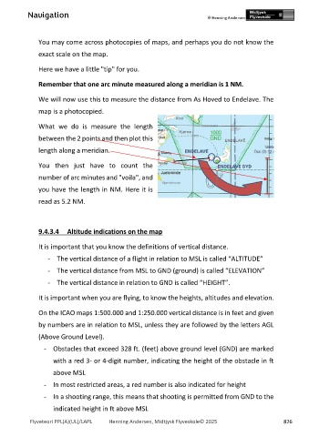
We will now use this to measure the distance from As Hoved to Endelave. The
map is a photocopied.
What we do is measure the length
between the 2 points and then plot this
length along a meridian.
You then just have to count the
number of arc minutes and "voila", and
you have the length in NM. Here it is
read as 5.2 NM.
9.4.3.4 Altitude indications on the map
It is important that you know the definitions of vertical distance.
- The vertical distance of a flight in relation to MSL is called “ALTITUDE”
- The vertical distance from MSL to GND (ground) is called “ELEVATION”
- The vertical distance in relation to GND is called “HEIGHT”.
It is important when you are flying, to know the heights, altitudes and elevation.
On the ICAO maps 1:500.000 and 1:250.000 vertical distance is in feet and given
by numbers are in relation to MSL, unless they are followed by the letters AGL
(Above Ground Level).
- Obstacles that exceed 328 ft. (feet) above ground level (GND) are marked
with a red 3- or 4-digit number, indicating the height of the obstacle in ft
above MSL
- In most restricted areas, a red number is also indicated for height
- In a shooting range, this means that shooting is permitted from GND to the
indicated height in ft above MSL
Flyveteori PPL(A)(UL)/LAPL Henning Andersen, Midtjysk Flyveskole© 2025 826