
Page 827 - PPL-engelsk 2025
P. 827
Navigation
- In addition, the height of larger hills and the height of national and
international airports are indicated. For both, ft. above MSL.
- Roads, towns and villages (brown (not all villages are named))
- Railways (black)
- High voltage power lines (red)
- Lakes and streams (blue)
- Forests (green)
When the map is lying on the table in front of you, it is difficult to see that it has
more than 2 dimensions. The 3rd dimension, the height, must be felt in another
way.
The starting point for all altitude in flight is the Danish Mean Sea Level (MSL).
Where the map is just with a white background, the terrain can be up to 250 feet
above MSL.
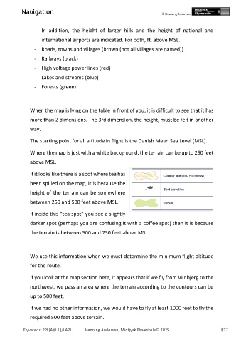
If it looks like there is a spot where tea has
been spilled on the map, it is because the
height of the terrain can be somewhere
between 250 and 500 feet above MSL.
If inside this “tea spot” you see a slightly
darker spot (perhaps you are confusing it with a coffee spot) then it is because
the terrain is between 500 and 750 feet above MSL.
We use this information when we must determine the minimum flight altitude
for the route.
If you look at the map section here, it appears that if we fly from Vildbjerg to the
northwest, we pass an area where the terrain according to the contours can be
up to 500 feet.
If we had no other information, we would have to fly at least 1000 feet to fly the
required 500 feet above terrain.
Flyveteori PPL(A)(UL)/LAPL Henning Andersen, Midtjysk Flyveskole© 2025 827