
Page 828 - PPL-engelsk 2025
P. 828
Navigation
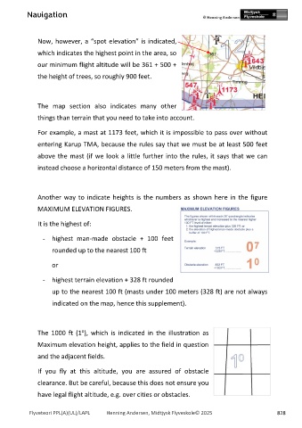
Now, however, a “spot elevation” is indicated,
which indicates the highest point in the area, so
our minimum flight altitude will be 361 + 500 +
the height of trees, so roughly 900 feet.
The map section also indicates many other
things than terrain that you need to take into account.
For example, a mast at 1173 feet, which it is impossible to pass over without
entering Karup TMA, because the rules say that we must be at least 500 feet
above the mast (if we look a little further into the rules, it says that we can
instead choose a horizontal distance of 150 meters from the mast).
Another way to indicate heights is the numbers as shown here in the figure
MAXIMUM ELEVATION FIGURES.
It is the highest of:
- highest man-made obstacle + 100 feet
rounded up to the nearest 100 ft
or
- highest terrain elevation + 328 ft rounded
up to the nearest 100 ft (masts under 100 meters (328 ft) are not always
indicated on the map, hence this supplement).
o
The 1000 ft (1 ), which is indicated in the illustration as
Maximum elevation height, applies to the field in question
and the adjacent fields.
If you fly at this altitude, you are assured of obstacle
clearance. But be careful, because this does not ensure you
have legal flight altitude, e.g. over cities or obstacles.
Flyveteori PPL(A)(UL)/LAPL Henning Andersen, Midtjysk Flyveskole© 2025 828