
Page 803 - PPL-engelsk 2025
P. 803
Navigation
9.2 The shape of the Earth and the grid
The Earth is shaped like a sphere (although it is slightly flattened at the poles).
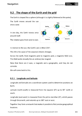
The Earth moves around the sun
once a year.
In one day, the Earth rotates once
around itself.
The rotation goes from west to east.
o
In relation to the sun, the Earth's axis is tilted 23½ .
This tilt is the cause of the seasonal climatic changes.
Across the earth, from magnetic pole to magnetic pole, a magnetic field runs.
This field works broadly like an ordinary bar magnet.
Note that there are 2 axes, a magnetic and a geographic, and they do not
coincide.
We will come back to this.
9.2.1 Longitude and latitude
Longitude and latitude are a coordinate system used to determine positions on
Earth.
Latitude (north-south) is measured from the equator (0°) up to 90° north or
south.
Longitude (east-west) is measured from the prime meridian (0°), which passes
through Greenwich, and extends up to 180° east or west.
Together they form a network that makes it possible to find precise geographical
locations.
Flyveteori PPL(A)(UL)/LAPL Henning Andersen, Midtjysk Flyveskole© 2025 803