
Page 15 - DPR Rishikesh Legacy_Neat
P. 15
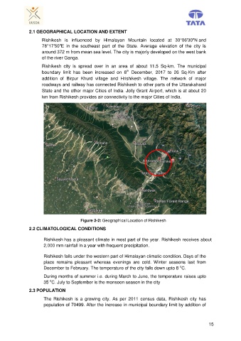
2.1 GEOGRAPHICAL LOCATION AND EXTENT

                      Rishikesh  is  influenced  by  Himalayan  Mountain  located  at  30°06′30″N and
                      78°17′50″E  in  the  southeast  part  of  the  State.  Average  elevation  of  the  city  is
                      around 372 m from mean sea level. The city is majorly developed on the west bank
                      of the river Ganga.

                      Rishikesh  city  is  spread  over  in  an  area  of  about  11.5  Sq-km.  The  municipal
                                                                th
                      boundary  limit  has  been  increased  on  8   December,  2017  to  26  Sq-Km  after
                      addition  of  Birpur  Khurd  village  and  Hrishikesh  village.  The  network  of  major
                      roadways and railway has connected Rishikesh to other parts of the Uttarakahand
                      State and the other major Cities of India. Jolly Grant Airport, which is at about 20
                      km from Rishikesh provides air connectivity to the major Cities of India.


                                         Figure 2-2: Geographical Location of Rishikesh

               2.2 CLIMATOLOGICAL CONDITIONS

                       Rishikesh has a pleasant climate in most part of the year. Rishikesh receives about
                       2,000 mm rainfall in a year with frequent precipitation.

                       Rishikesh falls under the western part of Himalayan climatic condition. Days of the
                       place  remains  pleasant  whereas  evenings  are  cold.  Winter  seasons  last  from
                                                                                          o
                       December to February. The temperature of the city falls down upto 8  C.
                       During months of summer i.e. during March to June, the temperature raises upto
                          o
                       35  C. July to September is the monsoon season in the city
               2.3 POPULATION

                       The  Rishikesh  is  a  growing  city.  As  per  2011  census  data,  Rishikesh  city  has
                       population of 70499. After the increase in municipal boundary limit by addition of


                                                                                                        15